


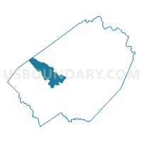
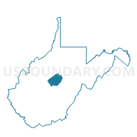
Voting District 23, Braxton County, West Virginia
About
Outline

Summary
| Unique Area Identifier | 690418 |
| Name | Voting District 23 |
| County | Braxton County |
| State | West Virginia |
| Area (square miles) | 23.45 |
| Land Area (square miles) | 23.42 |
| Water Area (square miles) | 0.03 |
| % of Land Area | 99.86 |
| % of Water Area | 0.14 |
| Latitude of the Internal Point | 38.68109090 |
| Longtitude of the Internal Point | -80.83226120 |
Maps

Graphs
Select a template below for downloading or customizing gragh for Voting District 23, Braxton County, West Virginia


Neighbors
Neighoring Voting District (by Name) Neighboring Voting District on the Map
- Voting District 26, Braxton County, WV
- Voting District 27, Braxton County, WV
- Voting District 6, Gilmer County, WV
- Voting District 9, Braxton County, WV
Top 10 Neighboring County Subdivision (by Population) Neighboring County Subdivision on the Map
- Southern district, Braxton County, WV (3,798)
- Western district, Braxton County, WV (3,694)
- Center district, Gilmer County, WV (1,690)